Imagine a giant hernia tucked beneath the Earth’s surface that pushes tectonic plates downwards as pressure builds before a powerful earthquake. By pushing the plates towards a liquid core, this hernia, or “tear,” as experts call this geological curiosity, acts as a seismic cushion.
On Monday, October 11, 12 seismic bursts were recorded in the Chicamocha Canyon, all spaced within 100 km of Mesa de los Santos. Just before midnight, a strong 4.9- magnitude quake shook the department of Santander and its capital Bucaramanga. The quake, with epicenter near Jericó, Santander, was also felt across the Magdalena valley in Medellín, Pereira and Ibagué. In Bogotá, the quake rattled furniture and startled residents.
Colombia is a fractured nation. River valleys break through canyons, Andean mountain ranges rise from tropical basins, and snowcapped volcanoes loom over small cities. Powerful tectonic movements are continually pushing and shoving the topography.
For geologist Carlos Alberto Vargas of the Universidad Nacional, the mineral fissure that slices across the Magdalena River valley won’t spare Colombia from devastating earthquakes – or a “Big One” as predicted for more than a century – but it does help defuse pent-up energies of colliding subducting plates. Vargas’ findings were published by the Seismological Society of America (BSSA) under the title ‘Caldas Tear resolves puzzling seismic activity beneath Colombia’.
According to this researcher, the fissure cuts East – West across the central regions of the country, absorbing pressure from three continental plates – Panama, Nazca, Caribbean – each nudging their way toward the other’s millennial territory. The existence of the Caldas Tear holds a deeper secret, believes Vargas, that reduces the “seismic impact on Bogotá.”
One curious aspect of the Caldas Tear is the ongoing displacement of Colombia’s volcano belt. While along the Central Cordillera, the Nevado del Ruíz, Tolima and Huila remain active, along the Eastern Cordillera, all volcanoes are dormant. For Vargas, the Caldas Tear is a natural boundary to the northern most limits of Colombia’s active volcanos, and evidence of East–West aligned volcanic rocks, suggest the tear ruptured the volcanic path.
Having studied more than 100,000 seismic events to identify how this fissure reacts, Vargas is convinced that the thick crust of the Panama plate also acts as an indenter, pushing the entire country towards the Pacific. When the intender rises towards the surface, it aggravates the so-called “Bucamaranga Nest,” rattling the Chicamocha Canyon and its slate of small towns. Mesa de Los Santos can experience up to 40 tremors every day.
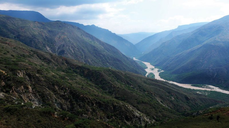
The Caldas Tear reveals itself in rugged terrain along the central Magdalena. As the river flows north from its origins in the Andean highlands, it narrows at Honda, in the department of Tolima, before opening as a rift valley near La Dorada, Caldas. “Everything we know about the Tear can be understood at the surface,” states Vargas, pointing to photographs taken of the Cauca River, near Supia, as it reduces to a narrow channel only 150-meters wide. At the narrowest points of both the Magdalena and Cauca are rich deposits of gold, platinum and copper. The majority of oil, gas and mineral extraction in the Magdalena valley take place along the Caldas Tear in sedimentary topography.
While picturesque Guane, Aratoca, Jericó and Mesa de la Santos are perched near the valve of a tectonic pressure cooker, for sprawling Bogotá, the existence of the Caldas Tear also protects this city from close-to-the-surface replicas, and that can be more devastating than a 5-magnitude earthquake, some 180 km deep. And while knowing that the Tear is there may be comforting, any movement beneath our feet is enough to keep us awake at night.